How the 10 richest cities of the world will fall – Post Apocalyptic Maps of Climate Change.
Posted by vonnagy on May 02 2016, in 10 richest cities, apocalypticpost, auckland, climate change, hong kong, london, los angeles, melbourne, san diego, san francisco, san jose, sea level rising, sydney, vancouver
The 10 most expensive cities in the world might become of the 10 least livable cities in the near future. This has less to do with real estate prices and more to do with the old adage “location, location, location’. The all of the 10 cities below are will be effected by rising sea levels given their close proximity to the ocean. Below is a list of the top 10 least affordable cities in the world as present by Demographia’s 2015 report:
| Least Affordable Rank | City | Country |
| 1 | Hong Kong | China |
| 2 | Vancouver | Canada |
| 3 | Sydney | Australia |
| 4 | San Francisco | United States |
| 5 | San Jose | United States |
| 6 | Melbourne | Australia |
| 7 | London | Great Britain |
| 8 | San Diego | United States |
| 9 | Auckland | New Zealand |
| 10 | Los Angeles | United States |
Each segment below looks at a certain change in sea level. While there is agreement that sea levels will rise, there is debate about how much it will rise. Here is a chart from IPCC.CH site(Intergovernmental Panel on Climate Change) which measures such things:
| Frozen water | Area | Ice Volume (106 km2) | Potential Sealevel Rise (SLE) (m)g |
| Snow on land * | 1.9–45.2 | 0.0005–0.005 | 0.001–0.01 |
| Sea ice | 19–27 | 0.019–0.025 | ~0 |
| Glaciers and ice caps | |||
| Smallest estimate | 0.51 | 0.05 | 0.15 |
| Largest estimate | 0.54 | 0.13 | 0.37 |
| Ice shelves | 1.5 | 0.7 | ~0 |
| Ice sheets | 14.0 | 27.6 | 63.9 |
| Greenland | 1.7 | 2.9 | 7.3 |
| Antarctica | 12.3 | 24.7 | 56.6 |
| Seasonally frozen ground * | 5.9–48.1 | 0.006–0.065 | ~0 |
| Permafrost * | 22.8 | 0.011–0.037 | 0.03–0.10 |
* Northern Hemisphere
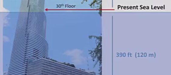
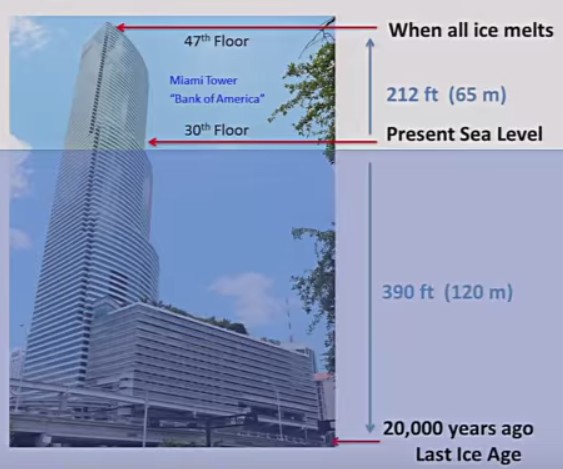
The worst case scenario is when all ice melts bring up sea levels potentially to 65 meters. The image below is a graphic from John Englander’s youtube presentation ‘Hide Tide on Main Street‘.
Some important and interesting points about this post:
- All cities above except for London are coastal cities.
- In nearly every instance Airports are the first to be flooded.
- I’ve converted property prices to USD for uniformity’s sake.
- Wherever possible, I’ve tried to express property prices to square foot for uniformity’s sake. However, different measurements are used in different countries so I used what ever information I could find.
Lastly, this is not a scientific research, I am just doing my best to compare where coastline flooding effects some world’s richest cities. I would highly encourage to come up with your own conclusions about the veracity of these findings.
Hong Kong
Hong Kong will start start having some serious problems at a 7 meter sea level rise:
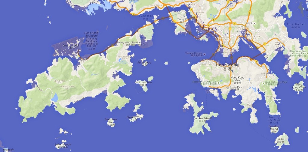
The brunt of this will on the New Territories Peninsula. Kowloon, where property prices average above 1200 per square foot, will also see flooding. In the Islands Distract, you will need to make sure your Airbus has pontoons to land, as it will be completely submerged if a system of dikes is not built. You might only see the mouse ears (instead of the whole mouse) as Hong Kong Disneyland will be mostly underwater.
Hong Kong Island, which is over $2000 USD per square foot, will have trouble around its forshore, particularly around Victoria Harbour.
Vancouver
Vancouver will start seeing problems at 3 meter rise – a 20 meter rise will be catastrophic.

At 3 meters, Vancouver Airport, Richmond, Delta and Surrey will have serious problems. In fact during questioning on the video High Tide on Main Street, a person comments that the airport and Richmond are essentially ‘canaries in a mineshaft’. Anywhere around the Fraser river valley will have to contend with extreme flooding. Granville Island will become at best a sand bar with a 5 meter rise.
The most expensive parts Vancouver, which include Kitsilano, Downtown and Mt Pleasant, where property prices are around $375 a square meter, will be submerged at 20 meters.
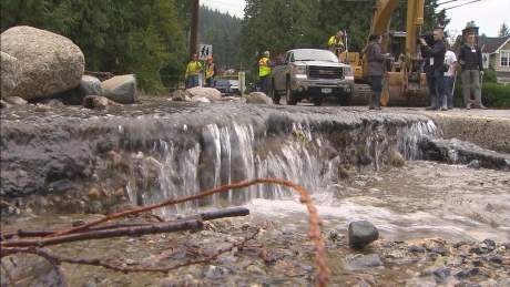
Although the Fraser Delta might look take the brunt of damage from sea level other parts are not immune. Severe flood damage took place on the Vancouver north shore in 2014; there major rivers area including Capilano River, Lynn Creek, Seymour River as well as several lakes and inlets that could damage the area from meltwater.
Sydney
The map below show Sydney, Australia with a sea level rise of 5 meters.
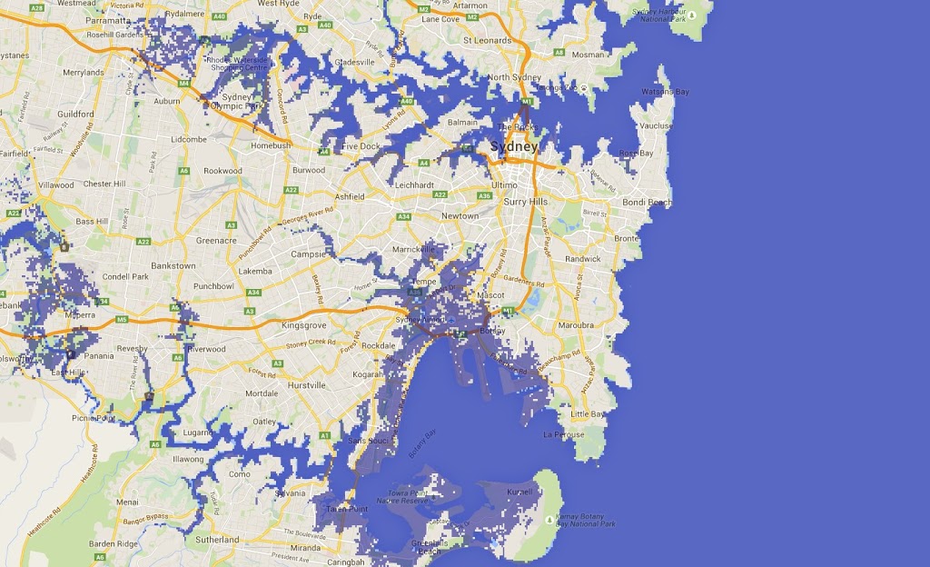
At the pictured level, Kingsford Smith Airport is mostly underwater, as are most commercial sections of Port Botany.
At 7 meters, most of the foreshore around Sydney Harbour is underwater, including Darling Harbour, the Rocks and Sydney Opera House. The following expensive suburbs are also affected, I’ve shown median house prices here:
- Point Piper – Median House Price $6,667,000
- Pott’s Point – Median House Price $2,270,000
- Rose Bay – Median House Price $2,040,000
- Double Bay – Median House Price $2,200,000
In addition secondary considerations about erosion should be considered, especially on Sydney’s southern coast. There is already concern about the Sea Cliff Bridge, and many other parts of South Sydney would be in danger from higher sea levels.
San Francisco
At 7 meters, San Francisco will start to reel from flooding.
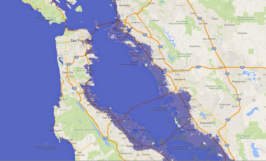
ATT park will become a part of McCovey Cove. Marina District, North Beach, Mission Bay, Dogpatch, all where properties can fetch well above $1000 per square foot will be mostly underwater. South San Francisco, SFO and all the way to Palo Alto with high waters. Across the bay, Oakland will be having problems of its own.
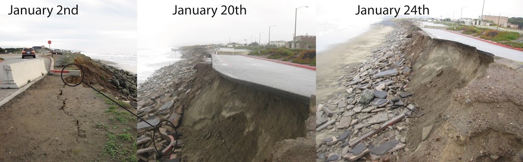
While the map above depicts problems in the bay, the coast areas will have their own set of issues. Ocean Beach on the west San Francisco is no stranger to erosion, as the photo below depicts. How much worse will it get when the sea level rises?
San Jose
Just a bit south of San Francisco, San Jose will start feeling the effects of sea rise at just 1 meter get dramatically worse after that. The map below shows San Jose under 3 meters of water.
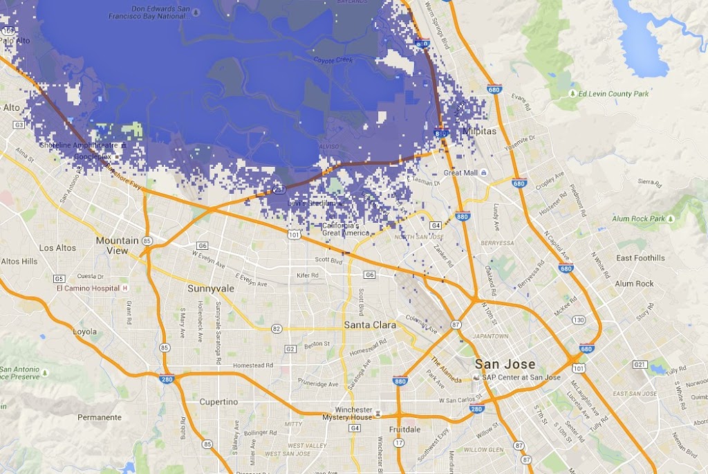
North San Jose, where property prices are over $500 per square foot would be the first part of San Jose to be effect. Larry Page and Sergei Brin will be taking their kayaks to the the Googleplex. Neighbouring Palo Alto where homes can be over $1000 per square foot is also in danger of being submerged.
Other features such as Moffett Federal Airfield, a Google’s own airport, Shoreline Amphitheatre and several parks and refuges will also be under water.
Melbourne
The map below shows Melbourne submerged beneath 9 meters of seawater.
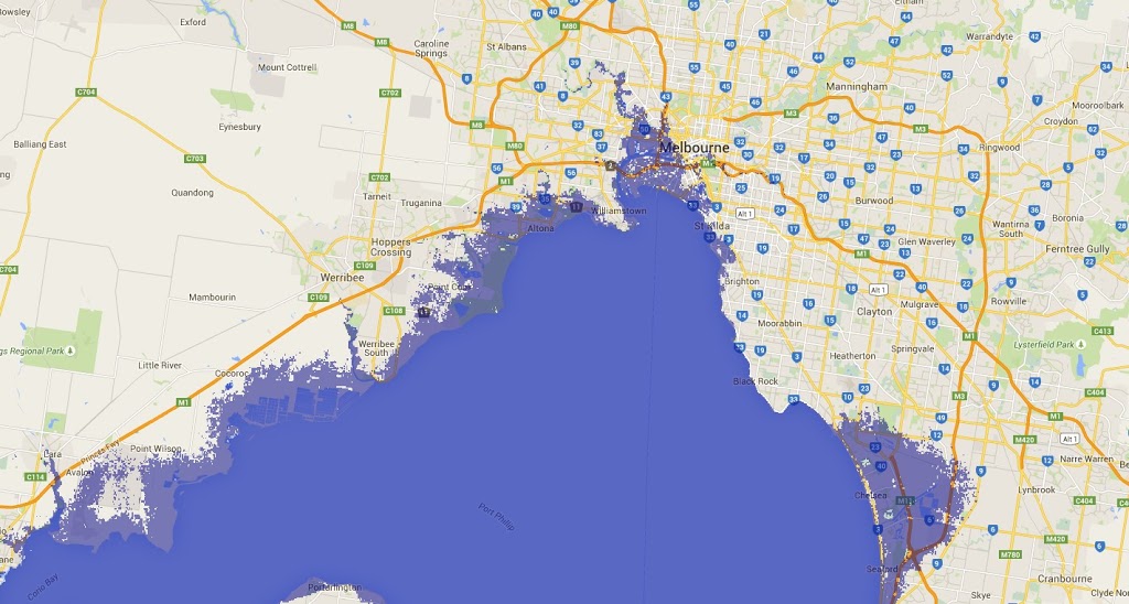
How will Melbourne’s most expensive suburbs fare? Here are some expensive Melbourne suburbs that are affected by rising sea levels.
- East Melbourne, roughly $630 per square foot, would see flooding around the cricket grounds
- Albert Park, roughly $530 per square foot. This suburb would be almost completely under water.
- Cremorne, about $380 per square foot, is particularly exposed around the banks of the Yarra river.
- St Kilda West – approximately $370 per square foot, would also be mostly submerged
Melbourne Tullamarine Airport, is one of the few airports in this post that is not affected; however, Avalon Airport which is further southwest on the coast is under water.
London
The only non-coastal city in this post, London, will still see significant damage from an increase in sea level. The map below shows a 7 meter rise.
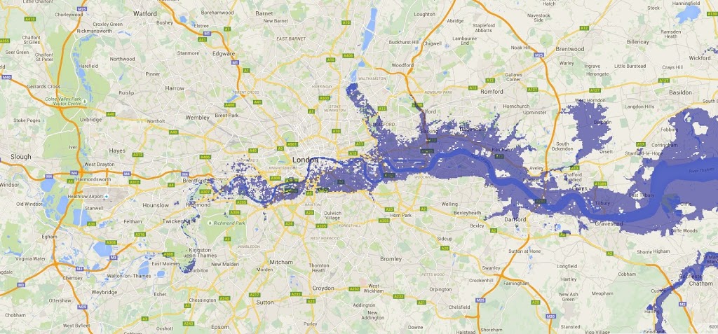
The Guardian has posted a heatmap of the most expensive properties in London in 2014. Here are some of the most expensive areas that may flood:
- Nine Elms, South Lambeth: $2600 per square foot
- Kennington, Southwark, Bermondsey, Wateroo: $2350 per square foot
- Wandworth: $1400 per square foot
- Rotherhithe, Surrey Docks: $1360 per square foot
Well known structures and landmarks such London City Airport, Canary Wharf, City Hall, Shakespeare’s Globe will all be affected.
Below is an image from the BBC which demonstrates the flooding that can take place on the River Thames:

San Diego
The map below shows the effects of a 5 meter rise in sea level in San Diego.
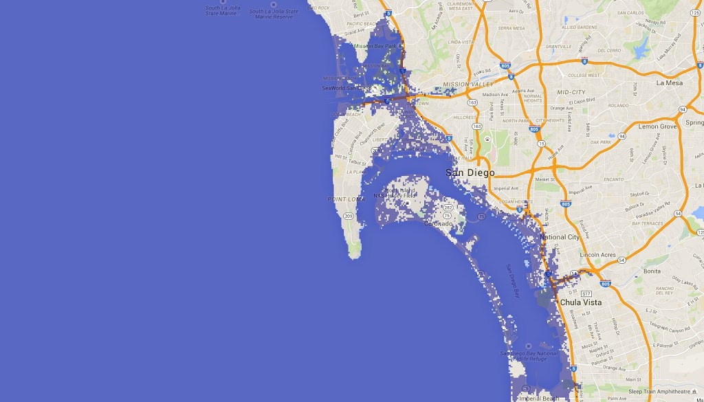
According to Trulia, here are some of the highest valued suburbs of San Diego affected by a rise in sea levels:
Mission Beach: $880 per square foot.
Ocean Beach: $673 per square foot.
Middletown: $572 per square foot.
Mission Hills: $532 per square foot.
In addition to the suburbs above the following areas and landmarks are also impacted by rising sea levels: SAN Airport, Naval Base Coronado, Fiesta Island, Seaworld, Old Town and parts of the San Diego River.
Auckland
Largest city in New Zealand is shown below under 7 meters of seawater:
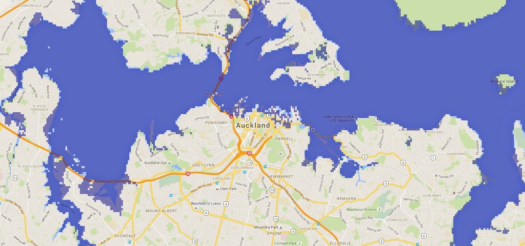
Unfortunately, I couldn’t find the price per square foot, but here are the most expensive suburbs that will be troubled by a rise in seawater:
- Herne Bay: Average home value: $1.18 m
- St Mary’s Bay: Average home value $1.09 m
- Remuera: : Average home value $ .98 m
- Westmere: Average home value: $ .87 m
- Devonport: Average home value $ .82 m
Currently, the city is developing the Wynyard Quarter. Currently the apartments being built there are valued at up to $3.2 million dollars. If sold this area could be one of the most expensive area in Auckland. Unfortunately, this is also the one of the most precarious areas as result of being land reclaimed from the sea. Maps indicate that the entire waterfront area including the Wynyard Quarter, Viaduct, Ports of Auckland and Judges Bay will all experience high levels of flooding.
Other areas affected include Auckland Airport, music venue Vector Arena and potentially the newly renovated Britomart area.
Additional maps of Auckland can be find on http://www.musther.net/nzslr/. These maps show scenarios of 10, 25 and 80 metre sea level rises.
Los Angeles
Our final city, Los Angeles is mapped below at 7 meters below level.
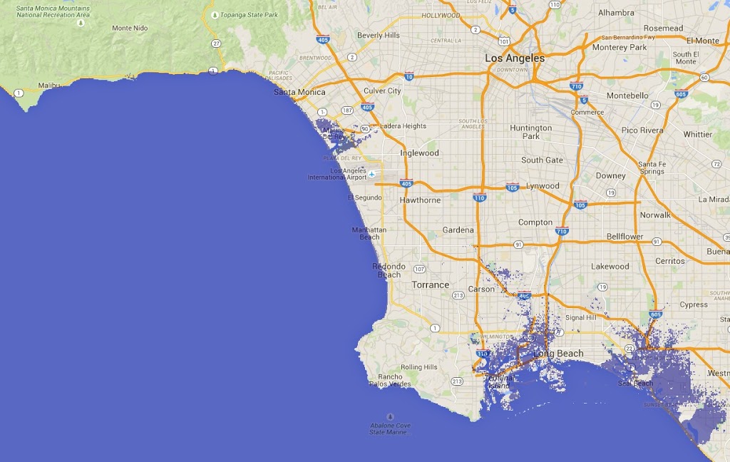
Seal Beach: $462 per square foot.
Huntington Beach: $440 per square foot.
Newport Beach: $747 per square foot.
Marina Del Ray: $717 per square foot.
Venice: $1,063 per square foot.
Los Angeles is interesting because its further inland. Property prices for some of affected are not a high as the cities listed above. At a 7 meter sea level rise, LAX airport is only has minor flooding, it doesn’t seem to get flooded out until about 30 meters. While the airport may be more resilient, the Ports of Los Angeles are not: Terminal Island will be nearly completely underwater at 7 meters.
So what can we learn from all this?
The richest areas are amongst the first go.
Its simplye to see that coastal areas are most desirable for the affluent, however these areas are the first to be affected by climate change.
Sea front lands are essentially leasehold lands.
This something that is emphasised by John Englander who wrote High Tide on Main Street. Lands near the ocean have a ‘limited’ timespan, unless serious engineering feats are made. Its better to consider these as leasehold lands.
Airports are at danger in nearly all locations. Because most airports require flat land that is commonly found at sea level (and often close to the ocean), this means that in most of the cities listed here are in danger.
Mitigate vs Adaptation.
Good news here that there are ways we can mitigate the effects of rising water. Adaption, on the other, will a rather expensive way to deal with this: forcing our will on the changing climate will be both expensive and impractical. Find ways to lessen the blow and work around rising sea levels is most pragmatic approach.
See excellent video below by John Englander which influenced this post:
JDJarvis
Dikes, stilts, move them inland. We are talking about the 10 richest cities.